
Abstract
Collier County, southwest Florida, experienced catastrophic flooding and building losses during Hurricane Ian (Cat-4, 2022) and Hurricane Irma (Cat-3, 2017). This study evaluates how sea level rise (SLR) and hurricane characteristics influenced these events to inform future preparedness. A 3D vegetation-resolving surge-wave model coupled with a parametric hurricane wind and precipitation model was used to simulate flooding for both storms. Estimated structural losses were $126.3 M (Irma) and $1.95B (Ian), with NFIP-insured losses within 7–12% of FEMA claims. Ian’s inundation corresponded to a 100–10,000-year flood, while Irma’s was mostly ~100 years, based on comparison with ~300 synthetic storm simulations. Losses were comparable to those expected from a 100-year flood (Irma) and 3500-year flood (Ian). Sensitivity analyses revealed that SLR, higher intensity, larger size, slower speed, more perpendicular track, northern landfall, and high tide amplified Ian’s impact. Climate change-driven SLR and intensity increases substantially heightened flood risk and damages.
Introduction
Hurricane Irma1 in 2017 and Hurricane Ian2 in 2022 caused significant coastal flooding and flood-induced building loss in Florida, particularly in southwest Florida (Fig. 1) where the hurricanes made landfall. Both hurricanes underwent Rapid Intensification (RI, i.e., increase of wind speed by 15 m/s within 24 hours) a few times before their Florida landfall. Forecast tracks for both hurricanes, particularly Ian, changed significantly prior to their landfall, due to interaction between the hurricanes and large-scale weather systems. Irma and Ian caused catastrophic damage in Florida, and rank as the second-costliest and the costliest hurricanes in Florida history. Ian ranks as the third-costliest hurricane in the U.S. history, next to Katrina in 2006 and Harvey in 20172.

a Study domain and distribution of mangroves and marshes in the eastern Gulf of Mexico region. Created from data provided by Florida Fish and Wildlife Conservation Commission using ESRI ArcGIS Pro 3.5. Basemap: Earthstar Geographics, sources: Esri, TomTom, NOAA, USGS, OpenStreetMap contributors and the GIS User Community. b Land cover map for Southwest Florida provided by Collier County. Created from data provided by Collier County using ESRI ArcGIS Pro 3.5. Satellite imagery: Earthstar Geographics, sources: Esri, TomTom, NOAA, USGS, OpenStreetMap contributors and the GIS User Community.
Hurricane Irma made landfall as a Saffir-Simpson Hurricane Wind Scale (SSHWS)3. Category-3 hurricane (with sustained wind of 178-208 km/h) on the south of Marco Island at 19:30 UTC on September 10, 2017, as primarily a windstorm which caused about $320 M of business and residential building damage in Collier County1. According to the FEMA (Federal Emergency Management Agency) National Flood Insurance Program (NFIP), Collier County received approximately $52.4 M in flood insurance claims4. At 19:05 UTC, September 10, 2022, Hurricane Ian made landfall at Cayo Costa Island, 30 miles north of Collier County, as a peak Category-4 (sustained wind of 209–251 km/h) hurricane, caused catastrophic building damage of approximately $2.2 B to 3515 buildings, with $1.7 B primarily flood damage to residential buildings in Collier County2. However, the latest FEMA flood insurance payout data for Collier County during Ian shows the flood loss is ~$777.4 M4, ~ 46% of the total estimated damage, comparable to the penetration ratio (percent of NFIP-insured households) of Collier County. During Irma, wind and flood damages on structures in Collier County were comparable but flood damage during Ian was dominant over wind damage, and much of the Irma damage was due to non-coastal damage due to wind and rainfall outside Collier County. Although both wind and flood hazards play significant roles in hurricane-induced building damage and that their combined effects should be considered for accurate damage assessments and disaster response planning, this study focuses on flood-induced building loss due to the lack of wind-induced building loss data which are proprietary property of private insurance companies.
Using a high-fidelity three-dimensional vegetation-resolving surge-wave modeling system CH3D-SWAN5,6 and its surrogate version, the Rapid Forecasting and Modeling System (RFMS)7, and extensive available data, this study simulates the coastal flooding and flood-induced building losses in Collier County during Irma and Ian and examines the causes for their dramatic differences. We first conduct simulations of the surge, wave, and flooding during Irma and Ian and compare them to extensive observed data at tidal gauges and High-Water Mark (HWM) locations. With the simulated maximum flood elevation during Irma and Ian, damage functions provided by the FEMA-HAZUS8 were utilized to estimate the flood-induced building loss during Irma and Ian and results compared to the FEMA flood insurance loss payout data4. Validation of county-level flood loss estimation during hurricanes can aid the improvement of FEMA damage functions and provide accurate estimation of flood loss during flood events of various return periods. However, due to uncertainty of the data (first floor elevation, buildings, and details of insurance claims and payouts), parcel-level analysis will require substantial effort and will not be performed in this study.
To gain insight on future hurricane response and planning, we assess the sensitivity of coastal flooding, in terms of Total Inundation Area6 (TIA) and Total Inundation Volume (TIV)6, to various factors that may affect the storm surge and flooding, including such hurricane parameters as intensity (central pressure deficit), Radius of Maximum Wind (RMW), forward speed (Vf), azimuth (angle of approach), and landfall location, as well as sea level rise and tide during Hurricane Ian. In combination with future hurricane trends predicted by climate models9,10,11, extensive analysis of historical hurricane data12,13,14 can be used for projecting potential coastal flooding and losses during future hurricanes.
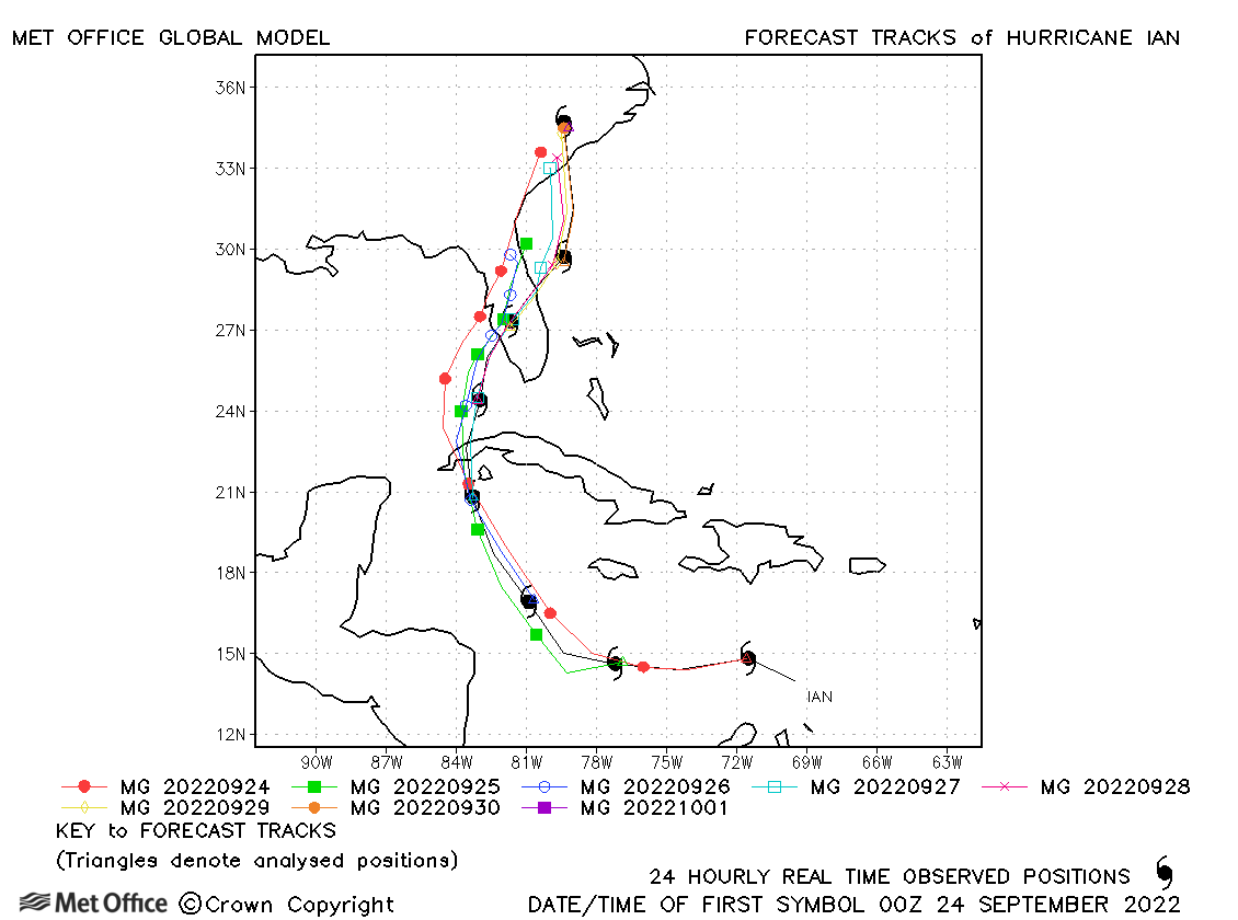
The best tracks of Irma and Ian1,2,12 are shown in Fig. 2. Figure 3 shows the shifting official forecast tracks (OFCL) for Irma and Ian at 48, 24, 12, and 0 hours prior to landfall12. Hurricane Irma and Ian made landfall on Marco Island1 and Cao Costa2, respectively, after underwent rapid intensifications prior to landfall. Irma’s RIs occurred on August 30-31 and September 4-5, followed by weaking with two less significant intensifications prior to its landfall as a Cat-3 hurricane at Marco Island on September 101,14. Ian had RIs on September 25 and then September 28, just seven hours prior to its landfall at Cayo Costa as a high-end Cat-4 hurricane2. Rapid intensification (RI) greatly elevates coastal flood hazards by increasing surge and flood impacts, particularly when it occurs within 24 hours of landfall, leaving minimal time for evacuation. Moreover, RIs made the forecasting of hurricane tracks a major challenge during Irma and Ian, as shown by the shifting parallel forecast tracks in Fig. 2. Consequently, any slight error in the cross-track direction would result in a significant error in landfall location.


For example, 12 hours before Irma’s landfall at Marco Island, it was forecasted to make landfall at Sarasota, 210 km to the north. 48 hours prior to Ian’s landfall at Cayo Costa, it was projected to landfall at Tampa, 225 km to the north. Based on the forecasted landfall location of Tampa, several Florida counties in the Tampa Bay region issued evacuation orders on September 26, two days prior to Ian landfall. Evacuees from Tampa to Orlando were hit with rainfall-induced flooding. Counties near the eventual landfall location did not issue evacuation orders until September 27, which resulted in more losses2. Therefore, to improve hurricane preparation of coastal communities, it is imperative to learn the impact of hurricane forecast error, which has been found to increase due to rapid intensification (RI) of recent hurricanes like Irma and Ian, on coastal flooding and to improve the accuracy and efficiency of forecast models. Even if hurricane forecast becomes more accurate at 48 hours prior to landfall, nevertheless, it is essential to improve the efficiency of the coastal flood forecasting system, which usually takes hours to days to run, to facilitate timely evacuations.
Observations from Hurricanes Michael (2018)15 and Ian (2022)16 show that RI can drive storm surges exceeding 4 meters due to sharp increases in wind speed and pressure drops near landfall. Coupled atmosphere-ocean models simulations confirm that RI enhances wind stress and wave setup, amplifying surge height and inundation extent, especially in low-slope coastal areas17,18. Climate projections indicate RI will become more frequent and intense with warming, compounding flood risks19,20. One study21, using downscaled synthetic cyclones and surge-rainfall models, showed that RI disproportionately increases 100-year flood exceedance probabilities in the North Atlantic. Another analysis22 found anomalously high subsurface temperatures (2–3°C above average) on the West Florida Shelf during Hurricane Ian, fueling its rapid transition from Category 3 to 5 over ~12 hours. A related simulation study attributed this intensification to strong latent heat fluxes and eyewall dynamics, despite vertical wind shear18. Additional research highlighted the role of warm shelf waters and limited upwelling in delaying storm-induced cooling and sustaining intensification18,22. Furthermore, the frequency of RI events within 400 km of coastlines has tripled since 1980, underscoring the growing threat to coastal communities21. Together, these findings show that RI significantly amplifies storm surge and inundation, demanding improved forecasting and adaptation strategies.
In the following, we present the results of our simulations on Irma and Ian flooding and flood losses, with verification based on available data. Followed by an assessment of how the flooding and flood losses during Irma and Ian compare with those of various return periods, e.g., the 1% Annual Exceedance Probability (AEP) flood, aka as Base Flood Elevation (BFE) or the so-called 100-year flood, to help us understand the adequacy of using the FEMA flood map as a guidance for community coastal flood preparedness. Special attention is given to the roles of various hurricane parameters in affecting coastal flooding and flood losses. Capability of existing surge-wave models for simulating the effect of RI on coastal flooding is discussed.
Results
Simulated vs. observed storm surge and high-water marks (HWMs)
Using the three-dimensional vegetation-resolving surge-wave modeling system CH3D-SSMS5 and the IPET (Interagency Performance Evaluation Team)23 version of the parametric hurricane wind model of Holland24, we simulated the surge, wave, and coastal inundation in the model domain shown in Fig. 1 for Hurricane Irma and Ian. Results of the simulations compared well with available data of surge and high-water marks (HWMs) at numerous stations shown in Fig. SI-1. Hurricane Irma weakened quickly within 24 hours of landfall at Marco Island, hence the resulting flood and building loss were mainly in Collier County. Hurricane Ian, however, caused significant flooding and flood loss in Charlotte, Lee, and Collier Counties.
The simulated surge at Naples during Irma agreed well with observed data at the NOAA Naples tide gage, as shown in Fig. SI-2(a). Simulated surge at Naples and Fort Myers during Ian agreed with observed data as shown in Fig. SI-2(b) and SI-2(c), respectively. Observed HWMs and peak water level are well captured by the model simulations, as shown in Fig. SI-3. The simulated HWMs improved slightly when waves are excluded from the simulation. Contributors to discrepancy between simulated and observed water level include accuracy of the parametric wind model and the surge-wave modeling system, input data, and observation error, etc.
Simulated maximum inundation and flood-induced building loss
As shown in Fig. 4, we compare the maximum inundations and flood-induced building loss during Irma and Ian. During Irma, high floods (up to ~4 m) and flood-induced building loss occurred near Marco Island where Irma made landfall and the sparsely populated area near Everglades City where relative flood loss reached up to 10% of the property value in these neighborhoods. During Hurricane Ian, Collier, Lee, and Charlotte Counties experienced a maximum inundation of 1–4 m, as shown in Fig. 4c. As a result, numerous neighborhoods suffered 5-10% building loss in Collier County.

a Maximum coastal inundation in Collier County during Hurricane Irma. Created from calculated data using ESRI ArcGIS Pro 3.5. Satellite imagery: Earthstar Geographics, sources: Esri, TomTom, NOAA, USGS, OpenStreetMap contributors and the GIS User Community (b) Flood loss (as percentage of total building value within each neighborhood area represented by the hexagons) during Irma. Created from calculated data using ESRI ArcGIS Pro 3.5. Satellite imagery: Earthstar Geographics, sources: Esri, TomTom, NOAA, USGS, OpenStreetMap contributors and the GIS User Community (c) Maximum coastal inundation in Collier, Lee, and Charlotte Counties during Hurricane Ian. Created from calculated data using ESRI ArcGIS Pro 3.5. Satellite imagery: Earthstar Geographics, sources: Esri, TomTom, NOAA, USGS, OpenStreetMap contributors and the GIS User Community. d Flood loss in Collier County during Hurricane Ian. Created from calculated data using ESRI ArcGIS Pro 3.5. Satellite imagery: Earthstar Geographics, sources: Esri, TomTom, NOAA, USGS, OpenStreetMap contributors and the GIS User Community.
Hurricane Irma and Hurricane Ian caused dramatically different maximum coastal inundation and flood-induced building loss in Collier County, even though their peak wind speeds were not that different: Irma was a Category-3 (112 mph or 50 m/s) and Ian was a Category-4 (150 mph or 67 m/s) hurricane at landfall. A close examination of the hurricane parameters showed that Ian was a slightly larger hurricane with a slower translational speed and made landfall in a direction almost perpendicular to the shoreline which generated high surge and wave. Due to Ian’s landfall location, the entire Collier County was subject to severe surge, waves, and flooding caused by the extreme onshore wind for many hours1. Irma, however, was dissipated by land shortly after landfall and most of Collier County was subject to wind blowing from the land to coast which did not generate any surge or wave1.
Using the damage function of FEMA-HAZUS, the estimated building loss in Collier County for NFIP-insured properties was found to be $59 M and $852 M, vs. the FEMA flood loss payout data of $52.4 M and $777 M, during Irma and Ian, respectively. Losses during Irma and Ian were both based on the 2022 property values which are available from Collier County.
One percent annual exceedance probability flood and resulting building loss
Recognizing the fact that coastal flooding depends on the combination of five hurricane parameters: intensity, size, translational speed, directionality, and landfall location, it is instructive to compare the maximum coastal inundation and flood-induced loss during Hurricane Irma and Hurricane Ian vs. those during a 1% AEP flood25 which represents the probabilistic coastal inundation due to a large ensemble of tropical cyclones determined according to the historical tropical cyclone climatology. The 1% flood map in Fig. 5a, determined by using the CH3D-SSMS modeling system and the JPM-OS (Joint Probability Method with Optimal Sampling) method26,27,28,29, shows inundation values comparable to the maximum inundation during Irma but lower than those in Ian. The total building loss induced by the 1% flood is found to be ~149.2 M, based on 2022 property values, which is comparable to the loss during Irma but much less than that during Ian, as shown in Fig. 5b. By comparing Figs. 4 and 5, it is apparent that the 1% AEP flood and the resulting flood-induced loss are higher than those for Irma but lower than those for Ian. Therefore, it would be of interest to examine the return periods of the maximum inundation during Irma and Ian.

a 1% Annual Exceedance Probability (AEP) Flood in Collier County. Created from calculated data using ESRI ArcGIS Pro 3.5. Satellite imagery: Earthstar Geographics. b Flood-induced building loss as percent of total building value within each neighborhood area (hexagon). Created from calculated data using ESRI ArcGIS Pro 3.5. Satellite imagery: Earthstar Geographics.
Return periods of flood and flood loss during Irma and Ian
To further elucidate this point, we calculated the return period of Irma flood and Ian flood at every single grid cell, by performing interpolation from an ensemble of maximum inundation maps for the “optimal storms” determined by the JPM-OS method. The resulting “return period map” for Irma flood and Ian flood are shown in Fig. 6. The IRMA return-period map shows the return period is generally less than 50 years for Collier County except the area to the southeast of the Irma landfall where return period reached up to 150 years. On the other hand, return period of Ian flood is less than 125 years in the southern county but is 100-10,000 years in the northern county. This is consistent with the observation that maximum surge during Ian had a return period of much greater than 100 years2.

a Irma return period map; (b) Ian return period map. While most of the county had ~100-yr flood during Irma, flood ranged from 100-10,000 years for Ian.
Figure 7a shows the Total Inundation Area6 (TIA) and Maximum Inundation Height6 (MIH) of the entire model domain for Irma, Ian, and flood of various annual exceedance probability (0.2 to 0.0001) or return period (5 to 10,000 years). Figure 7b shows the flood-induced building loss during Irma, Ian, and flood with 5–10,000 years return period. Irma’s MIH is slightly higher than that for the 100-year flood, while the TIA is comparable to that for the 100-yr flood. For Ian, MIH is comparable to the 500-yr flood while TIA compares to the 2000-yr flood. As a result, Irma’s building loss corresponds to a 100-yr flood, while Ian loss corresponds to a 3500-yr flood. It should be noted that the return periods correspond to flood driven primarily by storm surges and waves. Although seasonally averaged values of rainfall and river flow were included in the maximum inundation maps of the floods with various return periods, multi-variate copulas of these drivers were not considered here for simplicity. This is justified because flooding in Collier County during Ian was mainly due to storm surge instead of rainfall2. However, rainfall contributed more significantly to coastal flooding in Charlotte and Lee Counties to the north of Collier County during Ian2. A recent study17 showed that return period of extreme events varies significantly with the location as well as the estimation method which may consider one or multiple drivers that may be statistically correlated.

a Total Inundation Area (TIA) and Maximum Inundation Height (MIH) of Irma, Ian, and flood of various annual exceedance probability (between 0.2 and 0.0001) or return period (between 5 and 10,000 years). Created from calculated data using Mathworks Matlab R2024b. b Flood-induced building loss during Irma, Ian, and floods with various return periods between 5 and 10,000 years. It should be noted that loss for Hurricane Ian and return period flood is calculated in 2022 $USD, Hurricane Irma loss shown on this plot was adjusted to reflect the change in property market values from 2017 to 2022. Created from calculated data using Mathworks Matlab R2024b.
Dependency of coastal inundation on various factors
To assess the sensitivity of Ian flooding to a variety of factors including sea level rise, hurricane parameters, and forecast error, we utilized CH3D-SSMS5 as well as a highly efficient Rapid Forecasting and Mapping System (RFMS)7, developed from the maximum inundation maps of a large ensemble of ( ~ 300) historical storms. The RFMS includes the wave effects on surge and tides were included via the random timing approach where the tides are included in the model but the starting time for the tidal phase is randomized for each simulation. RFMS simulation agree with maximum inundation simulated by CH3D-SSMS over the model domain with an R2 of 0.87 for Ian and 0.84 for Irma.
With results for the 15 scenarios listed in Table 1, we examine the effects of hurricane forecast error (associated with official forecasts issued at 48, 24, 12, and 0 hours prior to landfall), radius of maximum wind (RMW), hurricane forward speed (Vf), hurricane intensity, timing of tide, as well as sea level rise (SLR) on the Total Inundation Area (TIA) and Total Inundation Volume (TIV)) in Collier County during Ian. Our chosen values of these parameters are consistent with those considered by other studies30,31, conform with observed data32, as well as climatologically possible27,33,34. Moreover, our studies on hurricanes in Southwest Florida29,33 found little correlation among the five major hurricane parameters.
As shown in Fig. 8, sea level rise from 1990 to 2022 and 2060 (shown by the red-colored bars) has the most significant impact on increasing TIA and TIV, while changing Vf (orange-colored bars) and RMW (yellow-colored bars) have similarly significant impact in increasing the TIA and TIV. Changing hurricane intensity (blue-colored bars) and timing of tide (green-colored bars) at landfall have somewhat less significant impact on increasing the TIA and TIV. As the forecast hour decreased from 48 hr to 0 hr, both TIA and TIV increased significantly, as shown by the black-colored bars). Rainfall was relatively low ( ~ 1-7” between 9/25-10/1/2022) in Collier County which is south of the Ian track, so its role in affecting coastal inundation was not very significant but more significant in Charlotte and Lee Counties to the north2.

a Total Inundation Area; (b) Total Inundation Volume. Created using Mathworks Matlab R2024b.
Clearly, had Ian occurred in 1990 when the sea level was lower, the coastal inundation would have been much less severe than in 2022. It is expected that in 2060, when the sea level is higher, coastal inundation could be a lot worse. In comparison with Irma, Ian had slower Vf and slightly larger RMW, leading to more inundation with larger TIA and TIV. Increasing the hurricane intensity alone or changing the tide from low tide to high tide at landfall alone did not increase the coastal inundation as significantly as the other drivers. To simulate the effect of rapid intensification of Ian during the 48 hours prior to landfall, we first compared the RFMS simulations using the hurricane parameters at 48 hours (not shown) and 0 hours (#1 in Table 1) prior to landfall based on the NHC Best Track. The results, although not included in Table 1, showed that rapid intensification increased the coastal flooding by 64% and 165% in terms of TIA and TIV, respectively. We then compared the results of Scenarios #1 vs. #4 and found that TIA and TIV increased by 83% and 230%, respectively. However, one could argue that these results reflect the effect of intensification (I) but not RI, because the RFMS results are obtained by specifying the landfall hurricane parameters rather than forced by time-varying hurricane parameters during the 48 hours prior to landfall.
To simulate the effect of Intensification (without RI) on surge and inundation, we used the landfall parameters for 48 hours prior to landfall to simulate Ian with CH3D-SWAN. The resulting surge and flooding are comparable to the CH3D-SWAN results for Ian. Therefore, we could not differentiate the effects of RI vs. I was on surge and inundation during Ian. As mentioned earlier, little rain was observed in Collier County during Ian, while 1000-year rain was observed in the Charlotte and Lee Counties to the north of the Ian track where the effect of RI was more pronounced. To reproduce the observed effect of RI on surge and rainfall in the region during Ian, dynamic coupling of a 3D baroclinic hydrodynamic model like CH3D-SWAN or FVCOM18 and a dynamic hurricane model such as HWRF18 is needed. However, it was found that the high observed surface temperature was significantly under-estimated by HWRF during Ian18, suggesting additional research is needed to improve HWRF to reproduce the complete RI cycle and its impact on surge and wave.
Importantly, 48 hours prior to Ian’s landfall, coastal communities were informed of a much less severe coastal flooding scenario than the actual one, thus highlighting the importance of improving hurricane forecast skill. During future hurricanes, RFMS could be used to predict potential coastal flooding scenarios based on forecast tracks issued by an ensemble of hurricane forecast models such as GFS35, ECMWF36,37,38, and UKMET39, etc. between 0-72 hours to aid planning effort.
Discussion
Using a 3D vegetation-resolving surge-wave modeling system, along with a parametric hurricane wind and rainfall model, we successfully simulated the coastal flooding in Collier County, Florida during Hurricane Irma and Hurricane Ian. Using the simulated flood and FEMA-HAZUS damage functions8, we simulated the vastly different flood-induced building losses during the two hurricanes. Validation of simulated flood and flood-induced building loss at the county provided the foundation for estimating county-wide flood and flood losses for flood events of various return periods ranging from 5 to 10,000 years. Flood during Irma was found to have a return period of less than 100 years with the flood loss with a return period of ~100 years. While Ian’s flood had return periods ranging between 200 and 10,000 years in the major populated areas and the return period of flood loss exceeding 10,000 years. With increasing storminess expected in the future, our results show that it is no longer safe to use the FEMA “100-year flood map” for engineering design benchmark along the Gulf and Atlantic coasts. Two recent studies29,33 found that, with rising sea levels and more untense hurricanes, future inundations in Southwest Florida could increase by a factor of 3-6 by 2100.
While observation data have shown how RI can significantly increase the storm surge and rainfall in coastal regions, no attempt is made to reproduce the effect of RI during Ian on coastal flooding in this study because it would require dynamic coupling of a 3D baroclinic hydrodynamic model such as CH3D-SWAN and a dynamic hurricane model such as an improved version of HWRF40, also because of the complex rainfall pattern with ~1000-year rainfall to the north of the Ian track but little rain to the south of the track in Collier County2. Using ensembles of TC tracks predicted by global circulation models (GCMs) for a different coastal region, recent model simulations21 showed that TCs with RI consistently resulted in higher surge and rainfall than those without RI.
Here in Fig. 9, we show the temporal changes of several hurricane parameters (RMW, Max Wind, Central Pressure, and Vf) during the 48 hours prior to landfall for a few recent hurricanes in the Gulf: Charley (2004, in BLUE), Wilma (2005, in PURPLE), Irma (2016, in YELLOW), Michael (2018, in ORANGE), and Ian (2022, in BLACK). As exemplified in the figure, more and more hurricanes now undergo rapid intensification before landfall thereby increasing surge, coastal flooding, flood losses, and uncertainties in forecasting.

Time-varying hurricane parameters: radius to maximum wind (a), maximum wind speed (b), central pressure (c) and translational speed (d) during the 72 hours prior and 24 hours after the landfall for Hurricanes Charley (2004), Wilma (2005), Irma (2017), Michael (2018), and Ian (2022). According to NHC definition, RI is defined as an increase of maximum sustained wind speed of 15.28 m/s in 24 hours. Therefore, all five hurricanes experienced RI at some point between 48-hr prior and landfall, but only Michael experienced continued RI in the 24 hours prior to landfall. Created using Mathworks Matlab R2024a based on analysis of two data sources: HURDAT267 and EBTRK most data is the same between datasets, however, radius to maximum wind (RMW) data is extremely sparse in the HURDAT dataset prior to 2021 and EBTRK reanalysis data were used instead.
The ways in which RI impact surge and flooding are rather complicated because of the interaction among the various hurricane parameters as well as the ocean circulation and temperature. Local bathymetric slope and natural and built environment can also influence the impact of hurricane on surge and flooding. For example, despite the strong winds during Charley and Wilma, surges and inundation extents were limited to local areas near landfall due to their much smaller RMWs as well as faster speed compared to the other hurricanes. Due to conservation of angular momentum, a hurricane undergoing intensification will experience increased atmospheric pressure gradient which leads to smaller RMW and stronger surface winds near the center which in turn leads to higher surge and but likely a smaller inundation extent up and down the coastline, as in Charley and Wilma. Faster speed and smaller RMW result in lower fetch for surge and wave to grow. Compared to Irma, Ian had stronger maximum wind and slightly larger RMW and size to cause higher surge and coastal inundation, consistent with the RMFS results shown in Figs. 7 and 8. RMW’s impact on surge and flooding can vary significantly with location and other hurricane parameters, e.g., smaller RMW could result in higher surge and inundation along a wide and shallow shelf or embayment34. Adding to the complexity, RMW values were not reported in the best tracks until 2021. Therefore, further modeling and observation studies are needed to better understand the potential effect of changing RMW on hurricane surge and flooding. Moreover, Ian’s slower forward speed and a more perpendicular hurricane track also contributed to higher surge and coastal inundation during Ian than Irma. Rainfall caused inland inundation in areas not covered by the CH3D-SWAN model domain.
Whether a more intense hurricane will lead to higher surge and inundation extent depends on all the hurricane parameters and their interactions with local coastal natural and built environments. A recent study33 compared predictions by several climate models and found that, while most models predict more intense hurricanes in the future, some models predict RMW and size will become smaller, yet others predict larger RMW and size. Ranges of variation of these parameters are comparable to those considered in this study shown in Table 1.
The 3D modeling system, along with its efficient surrogate model, was used to investigate the dependence of catastrophic coastal flooding during Ian to various climate and other physical factors. It was found that sea level rise has the most significant impact on the catastrophic flooding during Ian, followed by forward speed, radius of maximum wind, hurricane intensity, and tidal phase. Both Irma and Ian experienced repeated rapid intensification prior to their landfall, due to the very warm water in the Gulf of Mexico1,2,41,42,43,44 although Irma’s intensity decreased gradually within four days of landfall while Ian intensified from a Category-2 hurricane to a Category 4 hurricane within two days prior to the landfall Fig. 9.
Our results showed that rapid intensification and sea level rise, both attributable to climate change, are the two major contributing factors for the catastrophic flood and building loss in Collier County. Significant positive trends in storm surge during the last 50 years, found by a recent study45, are likely due to complex interactions between long-term changes in atmospheric forcings with rising mean sea-levels, both of which are significantly influenced by the rising sea surface temperatures (SSTs) which have been lasting longer and expanding across larger regions. With sea level expected to rise 25-cm along the U.S. coast by 205046 and increasing storminess in the future15,47,48, more catastrophic coastal flooding is expected in the future. Studies have shown that future coastal flooding will increase due to increasing hurricane intensity and sea level rise33. Moreover, future rainfall is expected to rise49,50,51. Therefore, to estimate the future flooding in coastal regions, it may be necessary to consider compound flooding due to the combined impact of coastal surge, waves, rainfall, and river flows using a multivariate statistical framework52,53,54. To enable simulation of the effect of rapid intensification on surge, rainfall, and flooding, the baroclinic version of CH3D-SWAN can be dynamically coupled to a hurricane model such as a further improved HWRF.
Methods
This study simulated flooding due to storm surge, wave, rainfall, and river flows in Collier County, Florida during Hurricane Irma and Hurricane Ian using a vegetation-resolving coupled surge-wave modeling system CH3D-SSMS and a version of the Holland parametric hurricane wind model that includes rainfall. The building loss during Hurricane Irma and Hurricane Ian was estimated using the FEMA-HAZUS depth damage functions8. The 1% flood and resulting building loss in Collier County are simulated using CH3D-SSMS, Holland hurricane wind model24, and the JPM-OS26,27,28.
Hydrodynamic modeling
Curvilinear-grid hydrodynamics in 3D (CH3D) is a hydrodynamic model originally developed by Sheng55,56,57 which simulate 2-D and 3-D barotropic and baroclinic circulation driven by tide, wind, and density gradients, and compared to other high-fidelity hydrodynamic models (e.g., ADCIRC58, POM59, and FVCOM60) in a regional storm surge model testbed61. CH3D is dynamically coupled to SWAN62 to simulate surge, wave, and flooding in coastal regions5,7. In addition, basin-scale ADCIRC or the 2D version of CH3D can be used to provide offshore open boundary conditions. Along the open boundary of the coastal model domain, sea level rise value is superimposed onto the water level obtained by ADCIRC or CH3D. This integrated storm surge modeling system5 can simulate flooding and drying with non-linear terms and has been used successfully to simulate storm surges along the US Atlantic and Gulf coasts during Charley, Wilma, Ike, Isabel, Sandy, and Irma. Charley, Wilma, Irma, and Ian significantly impacted SWFL. Details of the CH3D model and the SWAN model can be found in numerous papers5,6,62. The three-dimensional (3-D), vegetation-resolving CH3D-SWAN includes such dynamic vegetation-flow interactions as profile drag, skin friction drag, and production, dissipation, and transport of turbulence for various vegetations (laboratory vegetation6,63, Typha63,64, Spartina63,64, Phragmites63, and mangroves65) in submergent and emergent flows. A robust turbulent kinetic energy (TKE) closure model uses momentum equations with vegetation-induced profile and skin friction drags, a dynamic q2equation including turbulence production and dissipation by vegetation, as well as vegetation-dependent turbulence macroscale equations, and flow-dependent horizontal turbulence model. The vegetation-resolving CH3D-SWAN has been shown to produce accurate simulation on the reduction of storm surge and waves by various vegetations in idealized6, laboratory6,63, and field63,66 conditions, including real hurricanes including Andrew65, Sandy63,64, Ike66, Irma, and Ian. The vegetation and building information used for this study are described in the SI, with the vertical structures of various vegetation types in Collier County shown in Fig. SI-4.
Hurricane Irma and Hurricane Ian
The southern, western, and northern open ocean boundaries of the model are forced with linearly added predicted tides and storm surge elevation. The tidal constituents used in the model are M2, N2, K1, S2, O1, K2, and Q1. The surge boundary conditions for CH3D-SSMS were provided by a large-scale ADCIRC model to incorporate the remote effects of storm surges. Offshore wave conditions came from NOAA’s WaveWatchIII (WWIII: https://polar.ncep.noaa.gov/waves/ensemble/download.shtml) and river discharge data from the South Florida Water Management District (SFWMD) (https://www.sfwmd.gov/science-data/dbhydro).
Model domain spans from the Everglades in the south to Fort Myers beach with inland domain covering over 40 miles inland. The average grid size is ~10 m and the minimum (around the coast and densely populated areas near the City of Naples, etc.) is about 30 m. The total number of grid elements is about 1.8 million. The model is run using a 5 s time step and CH3D-SWAN coupling (information exchange) takes place every 10 minutes. For Irma and Ian simulation, observed river flow and rainfall data were used to drive the CH3D-SWAN model. Rainfall to the south of the Ian track was 1-7” between September 25 and October 1, 2022, but significantly higher just to the north of the track with 7-25”.
Storm ensemble
The JPM statistical method allows the generation of a set of all possible TCs according to the joint probabilities of the TCs predicted by the climate and downscaling models for a coastal region during a specific time interval (e.g., 20 years)33. A brief description of the JPM method and the more up-to-date JPM-OS method are provided in detail in Yang et al. 27.
Building loss calculations
The building data used in this study includes the parcels in the Microsoft US Building Footprints dataset (https://github.com/Microsoft/USBuildingFootprints), which was combined with the Collier County Property Appraiser parcel data, that provides attributes such as type of structure, market value, number of stories, etc. The monetary value used in the analysis was the market value reported by the Collier County Property Appraiser office (two versions of the data were used – 2017 data was used for Hurricane Irma estimates and 2022 version of the data were used for Hurricane Ian and maps with different return periods). Number of stories in a building was used from the provided data and was assumed to be equal to one where data are unavailable.
Flood above the first-floor elevation was calculated by interpolating inundation and significant wave height at the location of a building and calculating wave crest as inundation + 70% of the significant wave height (the 70% of the wave height is based on a FEMA guidance as a conservative estimate for the elevation reached by wave crests above Stillwater) and then the HAZUS damage functions were applied based on specific building type (e.g. single-family home, multi family home, mobile home, number of stories, etc.). Damage functions provide damage as percentage of building value at 1-foot increments, exact values were interpolated from these integer values. Total value was then calculated by adding together building loss within a polygon.
Due to the empirical nature of the HAZUS damage functions8 and uncertainties associated with various data including first floor elevation, building details, and insurance claims and payouts, it is impossible to conduct a parcel-level verification of the damage analysis presently. In this study, the estimated flood-induced building loss for the entire county agreed well with the FEMA NFIP flood loss payout data. First floor elevation is likely the biggest factor adding to the uncertainty of per-parcel analysis, we used the median value of first floor elevation from available data to assign to buildings where this data is not available (unavailable for most of the buildings in the county), however, the standard deviation for first floor elevation based on available data is about 4 ft, which greatly contributes to errors when calculating damages for individual buildings. Additional challenges exist due to the limited nature of the NFIP data that we have access to. NFIP claims are identified by an address, which creates uncertainty for large multi-unit condos and apartment buildings due to the lack of information about exact location of the unit (they are assumed to be located on the first floor). Also, naturally, multiple claims can exist against the same address, therefore we only compare totals for NFIP data rather than comparing individual claims. Regression analysis of NFIP claims vs estimated loss calculations show an R2 = 0.471 for Hurricane Irma and R2 = 0.711 for Hurricane Ian.
Data availability
The topography, bathymetry, and land-use datasets used in the regional and local studies are available via the sources described above. NFIP payout data is available from https://nfipservices.floodsmart.gov/reports-flood-insurance-data. Damage functions are available from the FEMA HAZUS U.S. Army Corps of Engineers (Physical Depth Damage Function Summary Report, North Atlantic Comprehensive Coastal Study: Resilient Adaptation to Increasing Risk). All data derived such as differences in losses and flood and wave heights between the two scenarios for the regional study, are available from the corresponding author on reasonable request and may be subject to a suitable Non-Disclosure Agreement.
Code availability
CH3D and SWAN have both been described in detail in the literature cited. Any inquiry about these models should be directed to the corresponding author and TU-Delft, respectively. Wetland coverage data are available from the corresponding author upon reasonable request.
References
Cangialosi, J. P., Latto, A. S. & Berg, R. Hurricane Irma (AL112017), National Hurricane Center Tropical Cyclone Report. https://www.nhc.noaa.gov/data/tcr/AL112017_Irma.pdf (2021).
Bucci, L. et al. Hurricane Ian (AL092022), National Hurricane Tropical Cyclone Report. https://www.nhc.noaa.gov/data/tcr/AL092022_Ian.pdf (2023).
National Hurricane Center, National Weather Service, NOAA. Saffir-Simpson Hurricane Wind Scale. https://www.nhc.noaa.gov/aboutsshws.php (2024).
OpenFEMA Dataset. FEMA NFIP Redacted Claims - v2. https://www.fema.gov/openfema-data-page/fima-nfip-redacted-claims-v2 (2024).
Sheng, Y. P., Alymov, V. & Paramygin, V. A. Simulation of storm surge, wave, currents, and inundation in the Outer Banks and Chesapeake Bay during hurricane Isabel in 2003: the importance of waves. J. Geophys. Res. 115, 1–27 (2010).
Sheng, Y. P., Lapetina, A. & Ma, G. The reduction of storm surge by vegetation canopies: Three-dimensional simulations. Geophys. Res. Lett. 39, L20601 (2012).
Yang, K., Paramygin, V. A. & Sheng, Y. P. A Rapid Forecasting and Mapping System of Storm Surge and Coastal Flooding. Wea. Forecast. 35, 1663–1681 (2020).
Federal Emergency Management Agency. HAZUS Flood Technical Manual, Federal EmergencyManagement Agency. https://www.fema.gov/sites/default/files/documents/fema_hazus-flood-model-technical-manual-5-1.pdf. (2022).
Knutson, T. R. et. al. Tropical cyclones and climate change assessment: Part I: Detection and attribution. Bull. Am. Meteor. Soc. 100, 1987–2007 (2019).
Knutson, T. R. Tropical cyclones and climate change assessment: Part II. Projections. Bull. Am. Meteor. Soc. 101, E303–E322 (2020).
Hall, T. M., Kossin, J. P., Thompson, T. & McMahon, J. U.S. Tropical Cyclone Activity in the 2030s Based on Projected Changes in Tropical Sea Surface Temperature. J. Clim. 34, T1321–T1335 (2021).
National Hurricane Center. Atlantic Hurricane database (HURDAT2) 1851-2023. https://www.nhc.noaa.gov/data/hurdat/hurdat2-1851-2023-051124.txt (Accessed July 31, 2023).
University of Wisconsin - Milwaukee. Hurricane Forecast Model Output. https://web.uwm.edu/hurricane-models/models/archive/historical.html (Accessed May 31, 2023).
Torgerson, W., Schwendike, J., Ross, A. & Short, C. J. Intensity fluctuations in Hurricane Irma (2017) during a period of rapid intensification. Weather Clim. Dynam. 4, 331–359 (2023).
Bhatia, K. T. et al. Recent increases in tropical cyclone intensification rates. Nat. Commun.10, 635 (2019).
McCann, M. et al. Field observations of Hurricane Ian’s wave and surge impact in the areas of Fort Myers Beach and Sanibel Island, USA. Coastal Engineering, 188, (2024).
Lin, N., Emmanuel, K., Oppenheimer, M. & Vanmarcke, E. Physically based assessment of hurricane surge threat under climate change. Nat. Clim. Change 2, 462–467 (2012).
Nickerson, A. K., Zhang, J. A., Weisberg, R. H. & Liu, Y. Rapid Intensification of Hurricane Ian (2022) in High Shear. JGR Atmosphere, 130, https://doi.org/10.1029/2024JD042024 (2025).
Emanuel, K. A. Tropical cyclones. Annu. Rev. Earth Planet. Scie.31, 75–104 (2003).
Murakami, H., Delworth, T. L., Cooke, W. E. & Hsu, P.-C. Detected climate change in global distribution of tropical cyclones. PNAS 117, 10706–10714 (2020).
Lockwood, J. W., Lin, N., Gori, A. & Oppenheimer, M. Increasing flood hazard posed by tropical cyclone rapid intensification in a changing climate. Geophys. Res. Lett.51, e2023GL105624 (2024).
Liu, Y., Weisberg, R. H., Sorinas, L., Law, J. A. & Nickerson, A. K. Rapid intensification of Hurricane Ian in relation to anomalously warm subsurface water on the wide continental shelf. Geophys. Res. Lett.52, e2024GL113192 (2025).
Interagency Performance Evaluation Task Force (IPET). Performance evaluation of the New Orleans and Southeast Louisiana Hurricane Protection System draft final report of the Interagency Performance Evaluation Task Force volume VIII. Engineering and operational risk and reliability analysis. (2006).
Holland, G. J. An analytic model of the wind and pressure profiles in hurricanes. Mon. Weather Rev. 108, 1212–1218 (1980).
Federal Emergency Management Agency. Flood Maps. https://www.fema.gov/flood-maps. (Accessed May 15, 2023).
Resio, D. T., Irish, J. L. & Cialone, M. A. A surge response function approach to coastal hazard assessment: part 1, basic concepts. Nat. Hazards 51, 163 (2009).
Yang, K., Paramygin, V. A. & Sheng, Y. P. An objective and efficient method for estimating probabilistic coastal inundation hazards. Nat. Hazards 99, 1105–1130 (2019).
Gori, A. & Lin, N. Projecting compound flood hazard under climate change with physical models and joint probability methods. Earth’s. Future 10, e2022EF003097 (2022).
Sheng, Y. P., Yang, K. & Paramygin, V. A. Predicting compound coastal inundation in 2100 by considering the joint probabilities of landfalling tropical cyclones and sea-level rise. Environ. Res. Lett.ume 17, 044055 (2022).
Vickery, P. J., Skerlj, P. F., Steckley, A. C. & Twisdale, L. A. Hurricane Wind Field Model for Use in Hurricane Simulations, 126, 1203–1221 (2000).
Willoughby, H. E., Darling, R. W. R. & Rahn, M. E. Parametric Representation of the Primary Hurricane Vortex. Part II: A New Family of Sectionally Continuous Profiles. Mon. Wea. Rev. 134, 1102–1120 (2006).
Knaff, J. A. et al. Improved Tropical-Cyclone Flight-Level Wind Estimates Using Routine Infrared Satellite Reconnaissance. J. Applied Meteorology and Climatology, 54, 463-478.
Sheng, Y. P. et al. A sensitivity study of rising compound coastal inundation over large flood plains in a changing climate. Sci. Rep. 12, 3403 (2022).
Irish, J. L., Resio, D. T. & Ratcliff, J. J. The influence of storm size on hurricane surge. J. Phys. Oceano., 38, (2003).
Sela, J. The derivation of sigma-pressure hybrid-coordinate semi-Lagrangian model equations for the GFS. NCEP Office Note #462, NOAA. 31pp. (2010).
Haiden, T. et al. Prates, F. Evaluation of ECMWF forecasts, including the 2021 upgrade. ECMWF Technical Memoranda #884. 56pp. (2022).
ECMWF (European Centre for Medium-Range Weather Forecasts), Forecast Charts and Data. https://www.ecmwf.int/en/forecasts. (accessed: May 21, 2024).
Bengtsson, L., Kanamitsu, M., Kallberg, P. & Uppala, S. FGGE 4-dimensional Data Assimilation at ECMWF. Bull. Am. Meteorological Soc. 63, 29–43 (1982).
Met Office, U. K. Forecast tracks for Hurricane Ian in 2022. https://www.metoffice.gov.uk/data/tropicalcyclone/tracks/nhem22/ian.gif (Accessed May 13, 2024)
Alaka, G. J. Jr. et al. Lifetime Performance of the Operational Hurricane Weather Researchnd Forecasting Model (HWRF) for North Atlantic Tropical Cyclones. Bull. Am. Meteorological Soc. 105, E932–E961 (2024).
Oguejiofor, C. N., Wainwright, C. E., Rudzin, J. E. & Richter, D. H. Onset of Tropical Cyclone Rapid Intensification: Evaluating the Response to Length Scales of Sea Surface Temperature Anomalies. J. Atmos. Sci. 80, 1971–1994 (2023).
Radfar, S., Moftakhari, H. & Moradkhani, H. Rapid intensification of tropical cyclones in the Gulf of Mexico is more likely during marine heatwaves. Commun. Earth Environ. 5, 421 (2024).
Thompson, P. R. et al. Sea level variability and change [in “State of the Climate in 2022. Bull. Am. Meteor. Soc. 104, S159–S162 (2023). .
Morim, J. et al. Observations reveal changing coastal storm extremes around the United States. Nat. Clim. Chang. https://doi.org/10.1038/s41558-025-02315-z (2025).
Emanuel, K. Evidence that hurricanes are getting stronger, Proc. Natl. Acad. Sci. USA. 117 (2020).
Marsooli, R. et al. Climate change exacerbates hurricane flood hazards along US Atlantic and Gulf Coasts in spatially varying patterns. Nat. Commun. 10, 3785 (2019).
Wang, P., Royer, E., Kendall, J. & Gutierrez, S. Impacts of Hurricane Ian along the Low-Lying Southwest Florida Coast (USA) in 2022: Lessons Learned. Journal of Coastal Research. 40. https://doi.org/10.2112/JCOASTRES-D-24-00003.1 (2024).
He, S. & Takemi, T. Future Changes of Extreme Precipitation and Related Atmospheric Conditions in East Asia under Global Warming Projected in Large Ensemble Climate Prediction Data. J. Clim. 37, 5171–5186 (2024).
Zhou, W. et al. Future precipitation increase constrained by climatological pattern of cloud effect. Nat. Commun. 14, 6363 (2023).
Myhre, G. et al. Frequency of extreme precipitation increases extensively with event rareness under global warming. Sci. Rep. 9, 16063 (2019).
Eilander, D. et al. A globally applicable framework for compound flood hazard modeling. Nat. Hazards Earth Syst. Sci. 23, 823–846 (2023).
Xu, K., Wang, C. & Bin, L. Compound flood models in coastal areas: a review of methods and uncertainty analysis. Nat. Hazards 116, 1–28 (2022).
Jane, R., Cadavid, L., Obeysekera, J. & Wahl, T. Multivariate statistical modelling of the drivers of compound flood events in south Florida. Nat. Hazards Earth Syst. Sci. 20, 2681–2699 (2020).
Zhang, Y. & Najafi. M. R. Probabilistic Numerical Modeling of Compound Flooding Caused by Tropical Storm Matthew Over a Data-Scarce Coastal Environment, Water Resources Research, 56, https://doi.org/10.1029/2020WR028565 (2020).
Davis, J. R., Paramygin, V. A., Forrest, D. & Sheng, Y. P. Towards the probabilistic simulation of storm surge and inundation in a limited resource environment. Mon. Weather Rev. 138, 2953–2974 (2010).
Sheng, Y. P. On modeling three-dimensional estuarine and marine hydrodynamics. Three-dimensional models Mar. Estuar. Dyn. Elsevier Oceanogr. Ser. 45, 35–54 (1987).
Sheng, Y. P. Evolution of a three-dimensional curvilinear-grid hydrodynamic model for estuaries, lakes, and coastal waters. Proc. 1st Int. Conf. Estuar. Coast. Modeling I 40, 49 (1990).
Luettich, R., Westerink, J. J. & Scheffner, N. W. ADCIRC: an advanced three-dimensional circulation model for shelves coasts and estuaries, report 1: theory and methodology of ADCIRC-2DDI and ADCIRC-3DL. Dredging Research Program Technical Report DRP-92-6, US Army Engineers Waterways Experiment Station 137 (1992).
Peng, M., Xie, L. & Pietrafesa, L. A numerical study of storm surge and inundation in the Croatan-Albemarle-Pamlico estuary system. Estuar. Coast. Shelf Sci. 59, 121–137 (2004).
Weisberg, R. H. & Zheng, L. Y. Circulation of Tampa Bay driven by buoyancy, tides, and winds, as simulated using a finite volume coastal ocean model. J. Geophys. Res. 111, C01005 (2006).
Sheng, Y. P. et al. A regional testbed for storm surge and coastal inundation models: an overview. in Proceedings of the 12th International Conference on Estuarine and Coastal Modeling, American Society of Civil Engineers. https://doi.org/10.1061/9780784412411.00028 (2011).
Booij, N., Ris, R. C. & Holthuijsen, L. H. A. third-generation wave model for coastal regions: model description and validation. J. Geophys. Res. 104, 7649–7666 (1999).
Sheng, Y. P. et al. Invasive Phragmites provides superior wave and surge damage protection relative to native plants during storms. Environ. Res. Lett. 16, 5 (2021).
Sheng, Y. P. et al. Role of wetlands in reducing structural loss is highly dependent on characteristics of storms and local wetland and structure conditions. Sci. Rep. 11, 5237 (2021).
Sheng, Y. P. & Zou, R. Assessing the role of mangrove forest in reducing coastal inundation during major hurricanes. Hydrobiologia 803, 87–103 (2017).
Lapetina, A. & Sheng, Y. P. Simulating complex storm surge dynamics: Three-dimensionality vegetation effect, and onshore sediment transport. J. Geophys. Res. Oceans 120, 7363–7380 (2015).
Landsea, Christopher W., Franklin, James L. & Beven, John L. The revised Atlantic hurricane database (HURDAT2) (PDF) (Report). US NOAA NWS. https://www.aoml.noaa.gov/hrd/hurdat/Data_Storm.html. (May 2025).
Acknowledgements
This paper is the result of research funded by the National Oceanic and Atmospheric Administration’s ESLR Program under award NA19NOS4780178 and RESTORE Science Program under award NA17NOS4510094 and to the University of Florida. Dr. Trevor Meckley was the project and technical manager of the ESLR project. Frank Parker and David Kidwell served as the project manager and technical managers respectively, of the Restore Science Program project. We thank Dr. Kevin Buffington of USGS for providing the bias-corrected DEM data and Dr. Christine Angelini for providing the vegetation structure data at selected stations.
Author information
Authors and Affiliations
Contributions
Y.P.S. oversaw the study and provided guidance with the model simulations and result analysis. V.A.P. led the numerical simulations of coastal inundation during Hurricane Irma and Ian, produced the 1% coastal flood maps, and analyzed the results. V.A.P. and Y.P.S. contributed equally to the writing of the manuscript.
Corresponding author
Ethics declarations
Competing interests
The authors declare no competing interests.
Additional information
Publisher’s note Springer Nature remains neutral with regard to jurisdictional claims in published maps and institutional affiliations.
Supplementary information
Rights and permissions
Open Access This article is licensed under a Creative Commons Attribution-NonCommercial-NoDerivatives 4.0 International License, which permits any non-commercial use, sharing, distribution and reproduction in any medium or format, as long as you give appropriate credit to the original author(s) and the source, provide a link to the Creative Commons licence, and indicate if you modified the licensed material. You do not have permission under this licence to share adapted material derived from this article or parts of it. The images or other third party material in this article are included in the article’s Creative Commons licence, unless indicated otherwise in a credit line to the material. If material is not included in the article’s Creative Commons licence and your intended use is not permitted by statutory regulation or exceeds the permitted use, you will need to obtain permission directly from the copyright holder. To view a copy of this licence, visit http://creativecommons.org/licenses/by-nc-nd/4.0/.
About this article

Cite this article
Paramygin, V.A., Sheng, Y.P. Coastal flooding in Southwest Florida during Hurricanes Irma and Ian. npj Nat. Hazards 2, 87 (2025). https://doi.org/10.1038/s44304-025-00141-z
Received:
Accepted:
Published:
DOI: https://doi.org/10.1038/s44304-025-00141-z
